
Parcel 10-2N-23-0000-0016-0050
Owners
PO BOX 399
CALLAHAN, FL 32011-0399
Parcel Summary
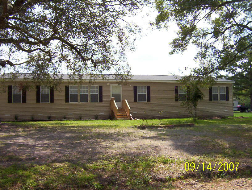
| Situs Address | 2623 RUBY DR |
|---|---|
| Use Code | 0200: MOBILE HOME |
| Tax District | 6: Drainage Dist |
| Acreage | 1.900 |
| Section | 10 |
| Township | 2N |
| Range | 23 |
| Subdivision | |
| Exemptions | None |
Short Legal
PT OF SECS 9 10 15 & 16PARCELS 5-3 16-5 6-11 & 1-3
2008 HOMI DW/MH...
Values
| 2025 Certified Values | 2026 Preliminary Values | |
|---|---|---|
| Land Value * | $85,500 | $76,000 |
| (+) Improved Value | $194,082 | $196,524 |
| (=) Market Value | $279,582 | $272,524 |
| (-) Agricultural Classification | $0 | $0 |
| (-) SOH or Non-Hx* Capped Savings ** | $37,697 | $6,451 |
| (=) School Assessed Value | $279,582 | $272,524 |
| County Assessed Value | $241,885 | $266,073 |
| (-) School Exemptions | $0 | $0 |
| (-) Non-school Exemptions | $0 | $0 |
| (=) School Taxable Value *** | $279,582 | $272,524 |
| (=) County Taxable Value | $241,885 | $266,073 |
Document/Transfer/Sales History
| Instrument / Official Record | Date | Q/U | V/I | Sale Price | Grantor | Grantee |
|---|---|---|---|---|---|---|
| QC 1503/1148 | 2007-06-05 | Q | Improved | $97,800 | MANGES HARRY E & MARTHA | BENTON JEFFREY A |
| AD 0910/0847 | 1999-12-06 | U | Improved | $35,000 | MANGES HARRY & MARTHA | BENTON JEFFREY & CHRISTINA |
| QC 0910/0845 | 1999-12-06 | Q | Improved | $0 | CARTER MARGARET A | MANGES HARRY & MARTHA |
| QC 0844/1875 | 1998-08-14 | Q | Improved | $37,000 | BRYANT JAY ROGER | CARTER MARGARET A |
| AD 0713/0083 | 1994-08-31 | U | Improved | $42,000 | CARTER MARGARET A | BRYANT JAY ROGER |
| WD 0711/0414 | 1994-08-12 | U | Improved | $41,700 | CASTLEBERRY JOHN & KENNA | CARTER MARGARET A |
| AD 0689/1292 | 1993-10-05 | Q | Improved | $42,000 | CARTER MARGARET | CASTLEBERRY JOHN & K |
| QC 0681/1998 | 1993-06-02 | Q | Improved | $100 | MANGES HARRY &MARTHA | CARTER MARGARET A |
| WD 0679/1435 | 1993-04-27 | Q | Improved | $48,000 | WRIGHT PHILLIS & L F | MANGES HARRY &MARTHA |
| AD 0628/1031 | 1991-06-13 | U | Improved | $100 | HORNE RONALD E | WRIGHT PHILLIS & L |
| AD 0421/0337 | 1984-05-01 | Q | Improved | $51,500 | ||
| MS 0276/0421 | 1978-10-01 | U | Improved | $100 |
Buildings
Building # 1
| Heated Sq Ft | Year Built | Value |
|---|---|---|
| 2280 | 2007 | $180,006 |
Structural Elements
| Type | Description | Code | Details |
|---|---|---|---|
| EW | Exterior Wall | 05 | AVERAGE |
| RS | Roof Structure | 03 | GABLE/HIP |
| RC | Roof Cover | 03 | COMP SHNGL |
| RC | Roof Cover | 01 | MINIMUM |
| IW | Interior Wall | 05 | DRYWALL |
| IF | Interior Flooring | 14 | CARPET |
| IF | Interior Flooring | 08 | SHT VINYL |
| AC | Air Conditioning | 03 | CENTRAL |
| HT | Heating Type | 04 | AIR DUCTED |
| BDR | Bedrooms | 4.00 | |
| BTH | Bathrooms | 2.00 | |
| FR | Frame | 02 | WOOD FRAME |
| STR | Stories | 1. | 1. |
| BUD8 | BUD8 Adjustment | 06 | DIST 1D |
Extra Features
Land Lines
Personal Property
None
TRIM Notices
Property Record Cards
Disclaimer
The Nassau County Property Appraiser's Office makes every effort to produce the most accurate information possible. No warranties, expressed or implied, are provided for the data herein, its use or interpretation. The information contained herein is for ad valorem tax assessment purposes only. The Property Appraiser exercises strict auditing procedures to ensure validity of any transaction received and posted by this office but cannot be responsible for errors or omissions in the information received from external sources. Due to the elapsed time between transactions in the marketplace, and the time that those transactions are received from the public and/or other jurisdictions, some transactions will not be reflected.